|
The Feel-Good Guide to Sports, Travel, Holidays & Entertainment
|
| Main | Sports Events | Holidays & Observances | Pop Culture | Travel |
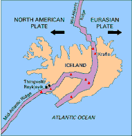
Main The Golden Circle Tour bus crosses a rift which our guide explains is actually the end of the continent of Europe. That is our introduction to Thingvellir National Park. Thingvellir, which you may also see written as Thingviller, is one of the four national parks in Iceland. What sets this one apart is the abundance of history and the forces of nature on display. It is one of the two areas on earth where you can actually see the ends of continents moving away from each other and it is the birthplace of government by the people in Iceland... the first democratic parliament in recorded history!
No other place in Iceland means as much to the the history of the Icelandic people. The name Thingvellir is translated as "Parliament Plains." This centrally located area is where the Alþing general assembly was established around 930 AD, just 60 years after Iceland was settled. The Alþing met in the shadow of the Lögberg or law rock, where the speaker addressed the gathered people. The theory is that the rock provided good acoustics so the crowd could hear what was being said. There were no microphones and public address systems in 930! The parliament continued to convene there until 1798 when it was moved to Reykjavik. The Parliament House, at Austurvöllur in Reykjavík, was built during 1880 and 1881. This is the oldest parliament still functioning. The Icelandic nation is justifiably proud of the history of government by the people that this represents. While the Alþing was an assembly to pass laws it was also a court and a general fairground. For two weeks every year all of Iceland would gather together to sort out disputes, trade goods and have a reunion. Typically, marriages would be brokered at these events as well. The people who came from the farthest northern areas would travel up to 17 days to be present. Ruins of the booths used during these annual meetings are still visible in the park. It was here that Christianity was declared the national religion of Iceland in the year 1000 AD. This is where Iceland declared its independance from Denmark. Many major events in the history of Iceland have taken place at Thingvellir. The area is very special to all Icelanders. Touring Thingvellir National Park Today Thingvellir is a national shrine protected by law so that the area will always be the property of the Icelandic people, under the protection of the Alþing. It has been named a UNESCO World Heritage Site to acknowledge "heritage considered to be of outstanding value to humanity." Our group walked across the Parliament Plains to the place where the law makers assembled. Long boardwalks straddle the field keeping the surrounding areas protected. This area is a scientific laboratory as well as an historic site.
As the group gathered by the the Lögberg, our guide explained the basics of plate tectonics which we were about to see first hand. According to the theory, the surface of the Earth is broken into large plates. These plates are slowly being moved by the spinning of the earth. The edges of these plates, where they move against each other, are sites of intense geologic activity, such as the earthquakes, volcanoes, and mountain building that are so characteristic of Iceland. Iceland sits on the Mid-Atlantic Ridge. The western part of the island is part of the Eurasian Plate. It is part of Europe. The eastern part of Iceland travels with the North American Plate. The plates are moving apart at about the same speed as fingernails grow. As the continents drift apart cracks, called fissures, form and provide a path for magma, molten rock, to move to the surface. The section of Iceland between the two plates constantly fills with magma creating new land. The opportunity to study the movement of the earth's land masses and the vegetation and other living things that settle in the newly formed land is a researcher's dream. For those who are less interested in research, the area provides an awe inspiring view of the edge of a continent. You walk along a rocky lava ledge that is the end of North America as you make your way back to the bus! After walking to North America, the group took the opportunity to visit a scenic overlook that features Lake Thingvallavatn. Lake Thingvallavatn is the largest natural lake in Iceland. The deepest part of the lake is below sea level.
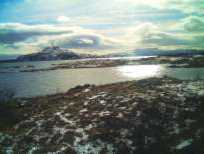
The lake fills a rift valley that extends south from the Langjökull glacier to the mountains and extinct volcano of Hengill. The eastern waters touch shores of rough lava where only the hardiest, primitive vegetation grows, but opposite on the Western shore you'll find magnificent rock formations and green farmlands. The scenery is spectacular. This is one of the few places in Iceland where many different types of trees are found, but the landscape remains stark. The lake waters are calm and crystal blue. Two islands sit in the middle of the lake but they seem very far away. A distant waterfall and a small set of white houses and a little church provide great photo ops. The bus is waiting for us, but there is time for a quick stop in the visitors center for souvenirs and brochures. This is one of the few man-made structures in the park nestled into this land of natural wonders.
Thingvellir National Park - UNESCO World Heritage Centre - The United Nations Educational, Scientific and Cultural Organization (UNESCO) added the park to its list of honored sites in 2004. "Our cultural and natural heritage are both irreplaceable sources of life and inspiration." This page explains why Thingvillir National Park fits this description. Thingvellir Wikipedia - An overall description of the Thingvellir National Park in Iceland with history, pictures and links to other resources.
|